ITIS DEVELOPMENT
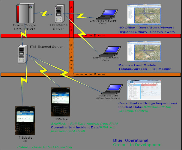
Due to the nonexistence of a commercial off the shelf (COTS) solution that could achieve the above requirements, the decision to develop and maintain and in-house bespoke solution was approved by the South African Roads Board in 1997. Since then the development of ITIS solution has progressed to currently consist of (see Figure):
- ITIS Web – Web enabled Geographical Information System (GIS) user interface providing online access to all technical Pavement, Structure, Traffic, Toll, Incident, Maintenance, etc. related data. Employees access the technical information within ITIS through a GIS based user interface as and when required. Thus, no static paper reports are produced, instead the user produces the feature rich, up to date information himself in the format he requires, i.e. paper printout, graphical report, GIS map report or in a spreadsheet. ITIS Web is currently on version 4 with 12 different modules. Work on Version 4.5 is currently in progress that will see the introduction of Google Earth as the map engine.
- ITIS Desktop – Offline data capture tool enabling consultants to capture information offline, validates the data when complete and if successful, allows consultant to synchronise the data with SANRAL ITIS server – this has been used very successfully with recent bridge inspections and now the capture of incidents under RRM contracts. Current versions 1.03 consist of Bridge Inspection and Incident Capture modules, modules currently under development include routine maintenance, as built data, project information and tender.
- ITIS Mobile – Smartphone solution that allows the in-field capture of information using a smart phone (must have camera and GPS), validates the data when complete and if successful, allows synchronisation of the data with SANRAL ITIS server. Current Version 1.01 includes following modules: Incident, Routine Maintenance, Pavement, Structure and Traffic. A mobile lite version will also be released to allow the public to capture basic defect information (i.e. potholes, broken fence, graffiti, litter, etc.) with their smart phones (must have GPS and camera) by selecting the defect type and then taking a photo.
Figure 1: ITIS Technology Landscape